Future City: Making the CBD more walkable
Consultation has concluded
This site was established during the early stages of the Future City campaign to build community understanding of the ideas behind the proposals. While these early stages of community consultation have now ended, this information continues to be available for research and reference purposes.
One of the main objectives of Future City is to make Orange’s CBD more walkable.
Orange City Council is looking at many ways to achieve this, including:
- reducing the speed limit in the CBD to 40km/h,
- introducing scramble crossings,
- nose-in parking and
- looking at the alternatives to roundabouts.
Council employed urban designers, SJB, to create ideasContinue reading
-
Council to ask community about 40km/h zone in the CBD
Share Council to ask community about 40km/h zone in the CBD on Facebook Share Council to ask community about 40km/h zone in the CBD on Twitter Share Council to ask community about 40km/h zone in the CBD on Linkedin Email Council to ask community about 40km/h zone in the CBD linkOrange City Council is asking the community what it thinks about whether the Central Business District (CBD) should have a 40km/h speed limit.
The proposal would reduce the speed limit from 50km/h to 40 km/h in the ‘inner’ blocks of the CBD, from Hill Street to Peisley Street and Byng Street to Kite Street.
Council will ask Transport for NSW to review the speed limit for the CBD, and as part of that review, Council will provide feedback from the Orange community.
Orange Mayor Reg Kidd said anyone who would like to have a say on the proposed speed limit review should register with Orange City Council’s YourSay website and participate in a survey.
“Council is very interested to hear from all sections of the community, from pedestrians, to cyclists, to business owners, people with disabilities and of course, drivers,” Cr Kidd said.
“It is important to note, TfNSW regulate speed limits in NSW for all roads therefore Council cannot change the speed limit. That final decision is up to Transport for NSW.”
Cr Kidd said Council had sought the support of the Orange Business Chamber for the proposed speed reduction review.
City of Orange Traffic Committee Chair Cr Russell Turner said the committee had reviewed crash data for the area and current actual speeds motorists travel through the CBD.
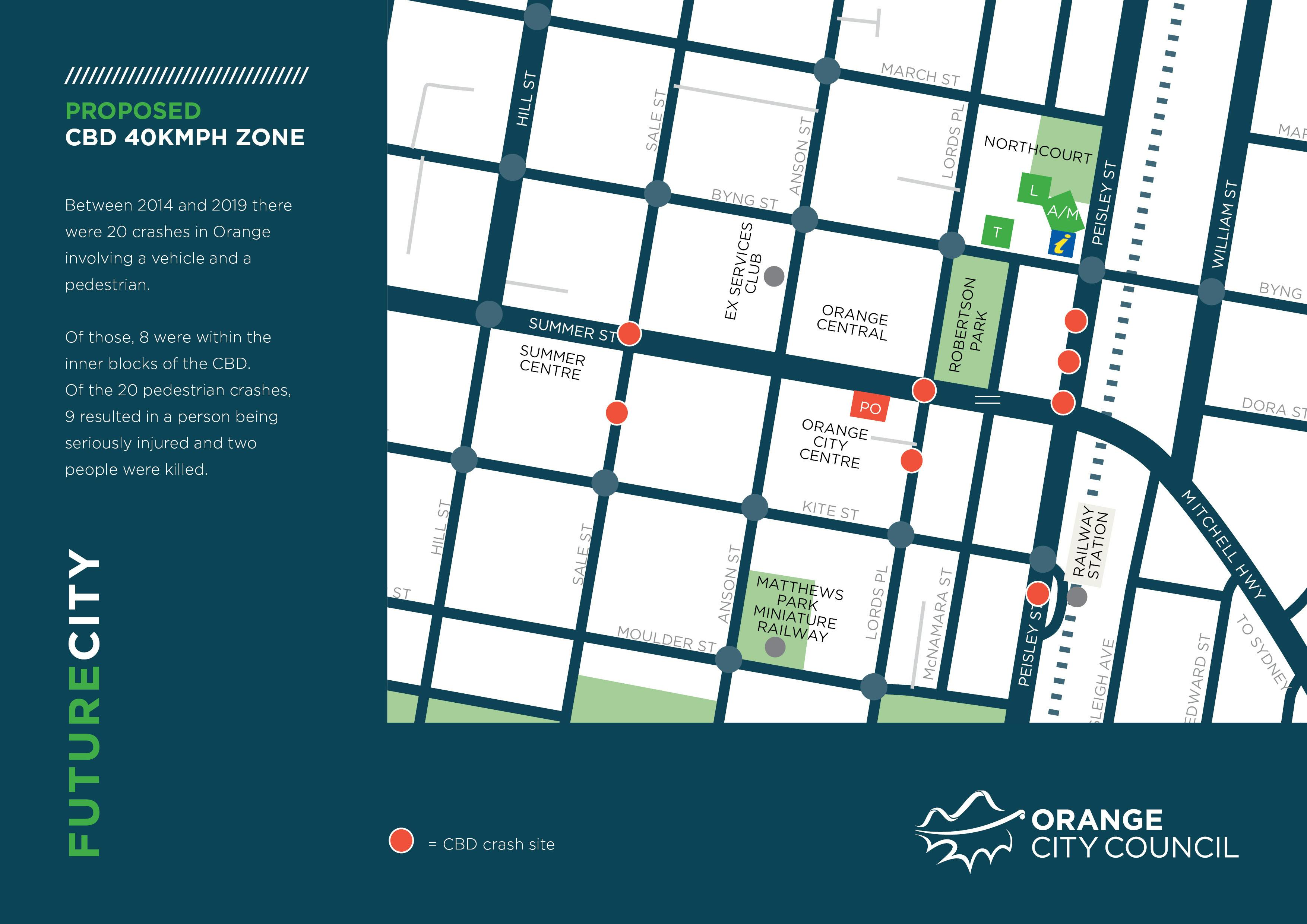
“Between 2014 and 2019, there were 20 crashes involving pedestrians in the city,” Cr Turner said.
“Of those crashes, 9 resulted in a serious injury, two people died.
“19 of those crashes were in a 50 km/zone and one was in a 40 km/h zone and that person had a minor injury.
“Studies show when reducing the speed of vehicles from 50km/h to 40km/h in a pedestrian and motor vehicle crash, the risk of having a pedestrian death is reduced from 60 per cent to 25 per cent.”
The proposal is part of Council’s Future City plans, which aims to make the CBD more walkable, it aims to attract more people to the CBD and increase the number of people living and working in the CBD.
Other ways to achieve a more walkable CBD are also being considered such as, scramble crossings, more cycle paths and footpaths and better lighting.
Data from the Orange CBD shows the actual average speeds cars travel in the CBD is rarely close to 50 km/h, however it is often above 40 km/h.
For example, 85 per cent of vehicles travelling westbound on Summer Street, from Anson Street to Sale Street average 44.3km/h.
In the other direction, the average speed is 47.2 km/h. The highest average speed in the CBD occurs on Sale Street, from Summer Street to Byng Street where motorists average 47.5 km/h.
Vehicles travelling along Summer Street from Hill Street to Peisley Street under a 40 km/h speed limit, would, on average, take an extra 7.87 seconds to complete the journey.
-
How will a change in speed zone affect travel times?
Share How will a change in speed zone affect travel times? on Facebook Share How will a change in speed zone affect travel times? on Twitter Share How will a change in speed zone affect travel times? on Linkedin Email How will a change in speed zone affect travel times? linkThe speed limit in the CBD is 50 km/h however traffic counters placed on the road measuring the average speed of vehicles showed motorists rarely reached 50 km/h.
The highest speed (85 per cent of motorists were within this speed) was on Sale Street, between Kite Street and Summer Street, where vehicles travelled 47.5 km/h.
On Sale Street, between Kite Street and Summer Street vehicles travelled 39.6 km/h.
On Summer Street, between Sale Street and Anson Street, westbound, vehicles travelled 44.4km/h, in the opposite direction they travelled 47.2 km/h.
On Peisley Street north of Aldi shopping centre vehicles travelled 45 kilometres per hour and south of Aldi they travelled 43.2 km/h.
Based off these speeds, engineers calculated the difference in travel time to drive from one end of the CBD to the other.
In Summer Street, from Hill Street to Peisley Street, westbound, a change to a 40 km/h speed zone would increase travel times by 7.87 seconds. In the opposite direction it would increase travel times by 12.36 seconds.
In Sale Street from Kite Street to Byng Street and in Anson Street from Kite Street to Byng Street, travel times were unlikely to change.
In Lords Pace from Kite Street to Byng Street, the increase in travel time was between 1.98 seconds and 5.46 seconds.
In Peisley Street from Kite Street to Byng Street travel times would increase by between 2.93 seconds and 4.4 seconds.
Traffic counters have not been placed on Byng Street nor Kite Street.
-
How does speed affect chances of survival?
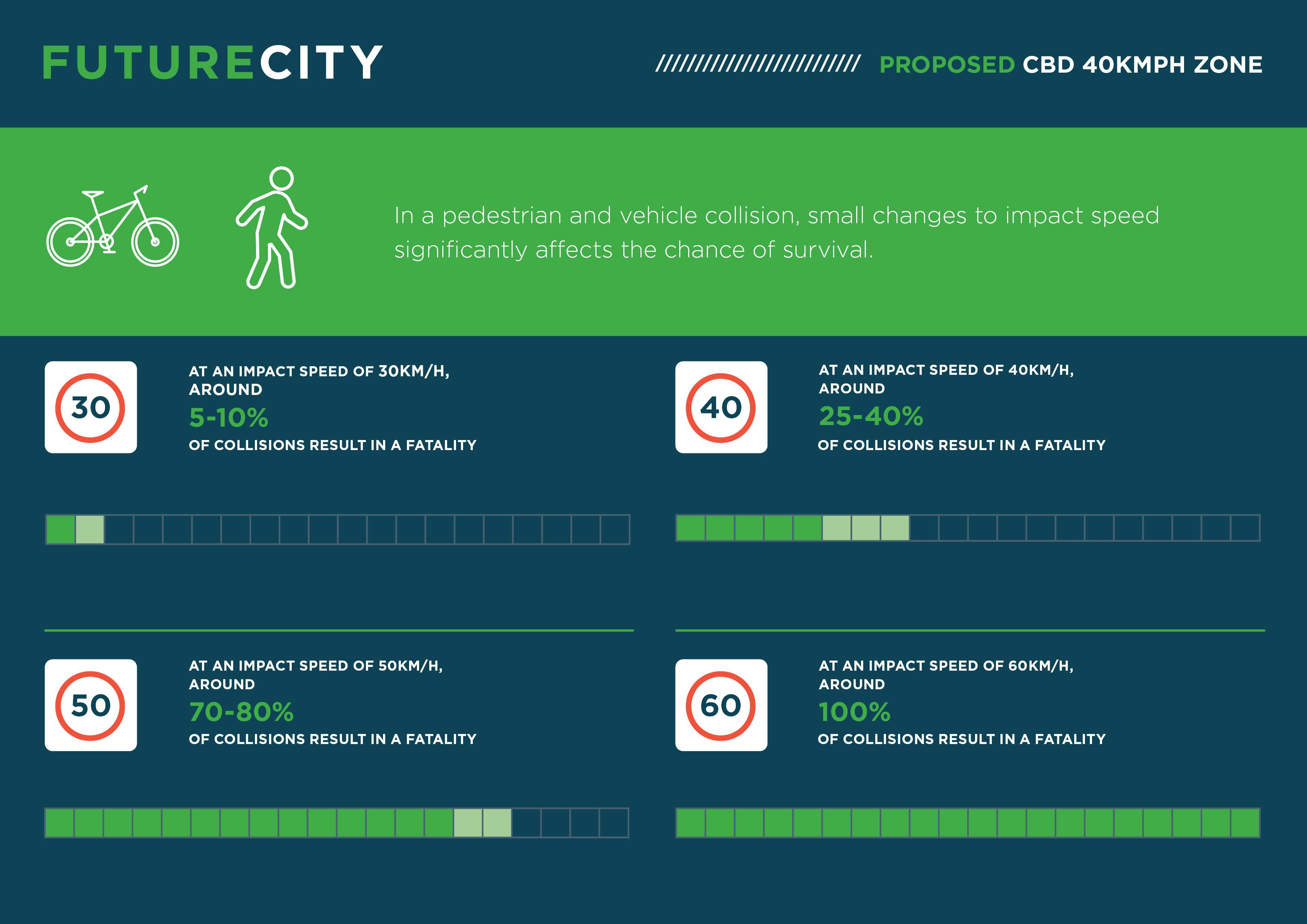
Share How does speed affect chances of survival? on Facebook Share How does speed affect chances of survival? on Twitter Share How does speed affect chances of survival? on Linkedin Email How does speed affect chances of survival? linkRoad safety data provided by state governments says a reduction of 5km/h in average travel speed would reduce ‘urban’ crashes by about 25 per cent.
A critical factor in the relationship between speed and crashes is stopping distance. There are two components to stopping distance:
- The distance travelled by the vehicle in the time it takes for the driver to react; and
- The distance travelled once the brakes have been applied.
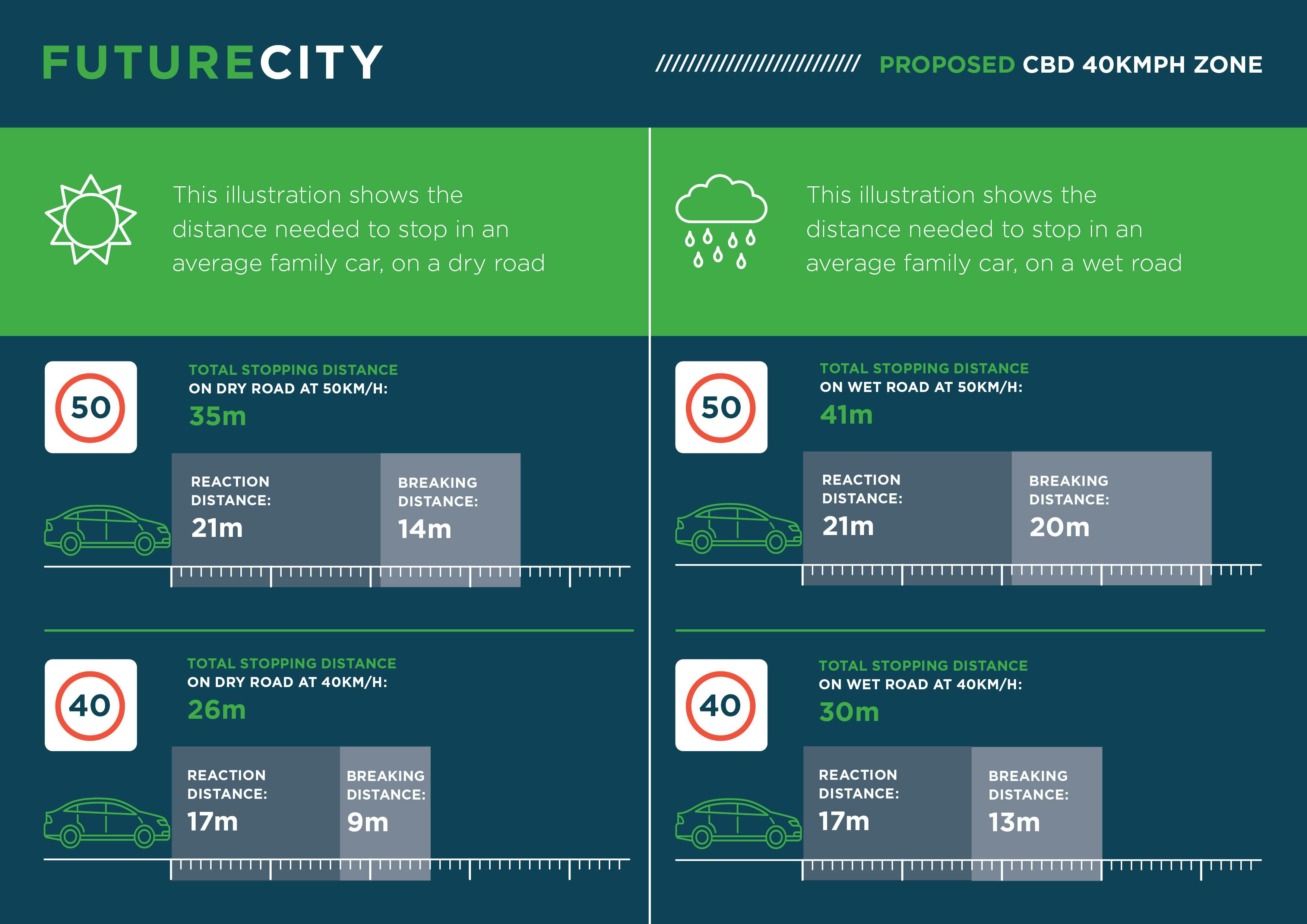
The faster a car is travelling, the longer it takes to stop. In an emergency, the average driver takes about 1.5 seconds to react. Stopping distances increase exponentially the faster the car is travelling.
At 40 km/h, on a dry road a driver takes about 26 metres to stop in an emergency. At 50km/h on a dry road a vehicle takes 35 metres to stop in an emergency.
The risk of pedestrian death rises exponentially with crash speeds above 30 km/h.
It is estimated that less than 10% of pedestrians would die when struck by a vehicle travelling at 30 km/h, compared with fatality rates of 26% at 40 km/h and over 80% at 50 km/h.
-
Crash data for Orange
Share Crash data for Orange on Facebook Share Crash data for Orange on Twitter Share Crash data for Orange on Linkedin Email Crash data for Orange linkMost vehicle crashes are reported to the centre for Road Safety, however crashes where no one is hurt and the vehicles exchange details and drive away are unlikely to be reported.
Council receives this crash data over a period of five years, known as the ‘crash period’. The crash period is always one year behind.
The current crash period is July 2014 to June 2019. This data is used to secure Blackspot road safety funding. The aim is make sure measures to improve safety are spent at locations where there's a history of accidents.
There were 619 vehicle crashes within the Orange Local Government Area (LGA) during the 2014 to 2019 crash period.
- 389 people were injured (taken to hospital for treatment) from the 619 crashes and 9 of the 619 crashes resulted in a fatality.
There were 20 pedestrian crashes within the Orange LGA during the crash period,
- 9 of the 20 crashes resulted in a serious injury,
- 5 resulted in a moderate injury,
- 4 resulted in a minor injury and
- 2 resulted in a fatality.
- 19 crashes were in a 50km/h zone,
- 1 was in a 40 km/h zone and it was a minor injury crash at Orange High School pedestrian crossing.
- 9 of the 20 pedestrian crashes occurred within the Orange CBD
- 13 of the 20 crashes occurred in daylight, 1 at dusk and 6 in darkness.
- 4 of the 20 crashes occurred at a pedestrian crossing, 1 at a stop sign, 1 at a give way sign, the remaining 14 pedestrian crashes were at a location where no traffic control existed..
The crash data does not describe exactly what the main contributor to the crash was or who was at fault.
-
Are roundabouts a blessing or an obstacle?
Share Are roundabouts a blessing or an obstacle? on Facebook Share Are roundabouts a blessing or an obstacle? on Twitter Share Are roundabouts a blessing or an obstacle? on Linkedin Email Are roundabouts a blessing or an obstacle? linkRoundabouts allow for the flow of traffic through an intersection without the vehicle needing to stop, however they can provide some challenges for pedestrians.
Roundabouts can be particularly difficult for people with mobility issues because unlike at a traffic light, vehicles in roundabouts never come to a complete stop, and pedestrians must instead rely on timing gaps between traffic. This is tricky for those with visual impairments or those who are unable to cross a lane of traffic quickly.
Two-laned roundabouts provide an additional challenge for pedestrians as they're forced to navigate an extra lane. Often there is a blind spot if there is a vehicle in the nearest lane, it can be difficult to see if there is any incoming traffic in the far lane.
Roundabouts are also more unsafe for cyclists. Speed and visibility of circulating vehicles are the major contributing factors to collisions with cyclists particularly as bicycles are often located where drivers do not look.
Roundabouts can be safer for vehicles rather than T-intersections with lights, as collisions generally occur at a reduced speed than they would if a car ran a red light.
Crashes are often at safer points on the vehicles, not head on, and not at a right angle but there tends to be more rear-end collisions.
-
Future City plan drives proposal for nose-in parking
Share Future City plan drives proposal for nose-in parking on Facebook Share Future City plan drives proposal for nose-in parking on Twitter Share Future City plan drives proposal for nose-in parking on Linkedin Email Future City plan drives proposal for nose-in parking linkRethinking the way Orange motorists use their cars is central to the Future City plan to transform the centre of Orange into a more walkable precinct.
Part of the plan is to slow cars down to make the area more pedestrian-friendly.
But, while slowing traffic down is safer for pedestrians, it is important to keep traffic flowing to avoid delays and frustration for motorists.
That’s why nose-in, angled parking has been proposed to replace rear-to-kerb parking and parallel parking in the CBD.
Austroads is the collective of Australian and New Zealand transport agencies, representing all levels of government.
The Austroads Guide to Traffic Management 2020 says angled parking can accommodate up to twice as many vehicles as parallel parking and nose-in angled parking is the preferred option in most situations.
In fact, it says, rear-to-kerb parking is illegal in a number of jurisdictions, such as South Australia.
Austroads prefers nose-in parking because:
- It keeps traffic flowing in a one lane traffic environment.
- Vehicle exhaust emissions face away from the footpath, pedestrians and outdoor dining.
- Vacant spaces are clearly visible and a motorist is able to slow down and move directly into a parking space causing little delay to following motorists.
- Motorists reversing out from the parking bay can select a time when passing traffic will not be disrupted.
- A stationary motorists about to reverse into the parking bay tends to disrupt passing traffic by trapping a vehicle behind.
- When parking, motorists can view high kerbs and footpath obstructions more easily.
- Motorists are not reversing into a pedestrian environment. Vehicle attachments such as tow bars and bicycle racks also pose a hazard to pedestrians when overhanging the edge of the kerb.
However, Austroads says rear-to-kerb parking has its applications, for example:
- When loading or unloading vehicles, because the rear of the vehicle is facing towards the footpath
- Reversing out of a nose-in parking space involves some of the vehicle protruding into the roadway before the driver can see oncoming traffic, affecting traffic and cyclist safety. A motorist about to drive forward from a rear-to-kerb space has a relatively good view of approaching traffic and cyclists.
Orange City Council encourages members of the community to share their feedback on the Future City plan.
-
Scramble crossings proposed for major intersections
Share Scramble crossings proposed for major intersections on Facebook Share Scramble crossings proposed for major intersections on Twitter Share Scramble crossings proposed for major intersections on Linkedin Email Scramble crossings proposed for major intersections linkOrange City Council plans to install several ‘scramble crossings’ in the central business district as part of the Future City project.
One major aim of the Future City project is to make the CBD more walkable and create alternatives for vehicles.
Scramble crossings at intersections involve stopping all vehicles in all directions for one ‘traffic light cycle’ letting pedestrians cross in any direction.
Scramble crossings would improve the CBD for pedestrian movement and would encourage cars to use alternate roads, rather than driving straight through the main street.
In NSW zebra crossing line markings are not painted on the road.
Part of Future City is about changing the CBD from a thoroughfare for traffic to a destination.
The plan is, Summer Street would be transformed from a highway into a high street, where people use their cars to casually cruise around, at a slower pace, park, then walk to various shops, cafes and restaurants.
Scramble crossings are proposed for key intersections:
- Lords Place/Summer Street
- Sale Street/Summer Street
- Anson Street/Summer Street.
The intersections are similar to the intersection near the Queen Victoria Building in George Street, Sydney and in Church Street in Parramatta where pedestrians walk in any direction when the traffic lights turn red.
Scramble crossings are used in locations in inner city New York and across Japan.
Scramble crossings are safer for pedestrians than traditional intersections as they remove cars from the intersection completely, rather than relying on cars to give way to pedestrians.
Providing a safer, more convenient experience for people crossing the street is a key way to get people walking more.
Making the CBD more walkable is better for local businesses.